
Written by Chris Goodell, P.E., D. WRE | WEST Consultants
Copyright © RASModel.com. 2008. All rights reserved.
I occasionally run into the desire to un-interpolate cross sections. I don't mean "delete" them, but to make them "real" cross sections, not interpolated. Typically this is so that I can interpolated between interpolated cross sections-if that makes any sense. Here's an example...you might have a set of surveyed cross sections that you want to merge with terrain cross sections you've cut in GIS. You have much more finely spaced cross sections from GIS and you want to merged the surveyed cross sections into the terrain cross sections. This is going to require you to interpolate between two cross sections to a specific location. RAS will allow you to do this, but will only allow you to do one cross section at a time. And it won't allow you to interpolate between interpolated cross sections. Therefore, you will have to uninterpolate your new cross section, so that you can interpolate between it and the next downstream surveyed cross section.
It's very easy to uninterpolate. Just go to the cross section editor and scroll to the interpolated cross section you want to fix. All interpolated cross sections in RAS end with an asterisk (*). In the editor, go to options...rename. Then just delete the asterisk. 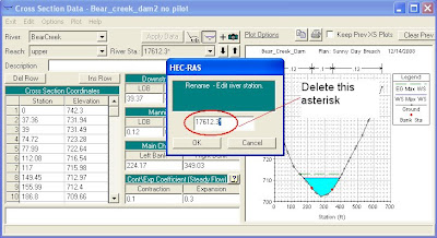 When I do this, I'll usually write a note in the description box saying that this is actually an interpolated cross section, even though it no longer has the asterisk. Here's the problem...if you ever want to make it an interpolated cross section again, you can't rename it and add an asterisk. RAS won't let you. In this case, you'll have to open up the geometry file in a text editor, find the cross section you want to chage and manually add in the asterisk at the end of the River Station.
 When I do this, I'll usually write a note in the description box saying that this is actually an interpolated cross section, even though it no longer has the asterisk. Here's the problem...if you ever want to make it an interpolated cross section again, you can't rename it and add an asterisk. RAS won't let you. In this case, you'll have to open up the geometry file in a text editor, find the cross section you want to chage and manually add in the asterisk at the end of the River Station.
First of all your blog is so helpful , im a intern cv from turkey and i was wondering how can i uninterpolate more than one xs ?
ReplyDeleteYou'll have to go through the cross section editor one at a time and rename then to remove the asterisk. Alternatively, you can go to the geometry window and select Tables...Names...River Stations, and there I believe you can edit them in a table format.
Delete