
Written by Chris Goodell, P.E., D. WRE | WEST Consultants
Copyright © RASModel.com. 2009. All rights reserved.
I just got a preview of the new release of HEC-RAS 4.0.1. Even though the release id would suggest it's a minor release with only bug fixes, there are (at least) two major additions to the software: Today I'll show you a little bit about the RAS Mapper. This will allow you to take your steady and unsteady flow results and map the floodplains directly within the HEC-RAS environment. In other words, you won't have to export into ArcGIS (at least not initially). The RAS mapper is a lot less complex than ArcGIS, but includes features like adding layers, defining projections, and inundation mapping. Inundation mapping requires a terrain model in floating point grid format (*.flt). These are very easy to create within ArcGIS. To finalize a map and smooth out the boundaries of the floodplain, you'll probably still have to go to ArcGIS. However, now you can just bring in your shapefile created in the RAS Mapper, as opposed to going through the PostRAS procedures in GeoRAS. Unfortunately, for now, GeoRAS is still required to create a geometry file from GIS.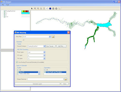

From the look of the new RAS Mapper, it appears that you simply select the profile you want to map, specify your terrain model, give it an output directory and click "Generate Layers".
Now I have to get a floating point grid set up so that I can give this a try...
Do Tell! Where does one get to download this version 4.0.1? Not from USACE website...
ReplyDeleteNo, it's not officially released to the public. Keep checking their website. Last I heard, they are looking at about a month before the official release.
ReplyDelete