Pages

Thursday, June 25, 2009

New Features 4.0.1 Part 2...Junctions

Written by Chris Goodell, P.E., D. WRE | WEST Consultants
Copyright © RASModel.com. 2009. All rights reserved.

Up until now, unsteady flow HEC-RAS uses a very simplistic method for handling juctions. It simply projected the water surface elevation of the downstream cross section to the two cross sections upstream of the junction. For shallow, deep systems, this worked fine-no problems. However, if you tried to model a steep reach with shallow depths you run into a host of problems at junctions. I've blogged about this problem before and provided examples of ways around to work around it. However, in the new version soon to be released (4.0.1) HEC has taken care of this problem and it works quite nicely.

In the Junction Editor, you'll notice that there is a new option for unsteady flow.

You can either keep the original, simplistic computation mode, or require RAS to perform an energy balance around the junction. I'm assuming HEC left the original "Force Equal WS Elevations" method in as the default so that your results will remain the same when you upgrade to 4.0.1. I don't believe that the new method is computationally burdensome, so I would expect that for new models, you'll want to check the "Energy Balance Method", particularly if you'll be working with steep reaches and/or shallow depths.

Monday, June 15, 2009

New Features 4.0.1

Written by Chris Goodell, P.E., D. WRE | WEST Consultants
Copyright © RASModel.com. 2009. All rights reserved.

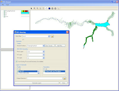
I just got a preview of the new release of HEC-RAS 4.0.1. Even though the release id would suggest it's a minor release with only bug fixes, there are (at least) two major additions to the software: Today I'll show you a little bit about the RAS Mapper. This will allow you to take your steady and unsteady flow results and map the floodplains directly within the HEC-RAS environment. In other words, you won't have to export into ArcGIS (at least not initially). The RAS mapper is a lot less complex than ArcGIS, but includes features like adding layers, defining projections, and inundation mapping. Inundation mapping requires a terrain model in floating point grid format (*.flt). These are very easy to create within ArcGIS. To finalize a map and smooth out the boundaries of the floodplain, you'll probably still have to go to ArcGIS. However, now you can just bring in your shapefile created in the RAS Mapper, as opposed to going through the PostRAS procedures in GeoRAS. Unfortunately, for now, GeoRAS is still required to create a geometry file from GIS.

From the look of the new RAS Mapper, it appears that you simply select the profile you want to map, specify your terrain model, give it an output directory and click "Generate Layers".
Now I have to get a floating point grid set up so that I can give this a try...

Wednesday, June 3, 2009

Energy Grade Line Problems

Written by Chris Goodell, P.E., D. WRE | WEST Consultants
Copyright © RASModel.com. 2009. All rights reserved.

Why do you sometimes see the water surface elevation and the total energy increase in the downstream direction? The energy grade line should always slope downhill. Water surface doesn’t necessarily have to though (i.e. hydraulic jumps, transition from narrow cross section to wide cross section). In this case, I’m not sure what the problem is without seeing the model firsthand, but the EGL indicates localized errors. This usually occurs from either not enough cross sections, or HTAB computation points that are too coarse, or the computation points don’t go low enough in the cross section. Try maxing out the number of HTAB points for each cross section, and decrease the increment as well. Also, use the invert of the channel as the starting computation point (there’s a button to do that automatically). Run the model. If there are still some problems, try interpolating some cross sections in the areas where there is increasing energy. Also, turning on the critical depth variable in your profile plot can help to explain what’s going on.

HEC-RAS Help or Troubleshooting

Written by Chris Goodell, P.E., D. WRE | WEST Consultants
Copyright © RASModel.com. 2009. All rights reserved.

I wanted to take the opportunity to throw out a few resources for finding HEC-RAS help and troubleshooting models. First off, unless you work for the Corps of Engineers, HEC can not offer technical support to you. They are happy to receive bug reports from anyone, but for help on methods, concepts, and general how-to's, they are just not equipped to handle it. You may be surpised at how small (in #s of employees) HEC really is. Anyway, when I'm looking for help, I usually consult the manuals first. Now-a-days, you can get to the manuals directly though the Help menu item in HEC-RAS. These manuals are very well written. It is quite possible that the answer to your question is already documented in the manuals. Also, check the Release Notes, and "What's New" documents on the HEC web site (http://www.hec.usace.army.mil/).

If that doesn't help, search this blog, using the search tool on the right side bar.

Still no luck? Try a forum dedicated to HEC-RAS. The Boss website has a great forum for HEC-RAS (among other software and topics). It has been around for a long time and has countless postings. Be careful though. I'm not sure how well this forum is moderated and I've seen some very bad suggestions and just completely erroneous replies. http://www.bossintl.com/forums/hec-ras/

This is partly the reason I started the HEC-RAS Bloggery Forum. Although it it very new and there's not a lot on there yet, I moderate all postings and replies. If something is posted that is not accurate, it will be corrected or removed.
http://forum.rasmodel.com/user/categories.aspx

Still no luck? There's always the option of getting professional consultation and technical support from an expert in the field. Of course, this is where I shamelessly plug WEST Consultants. www.westconsultants.com

Tuesday, June 2, 2009

0.00001 ft

Written by Chris Goodell, P.E., D. WRE | WEST Consultants
Copyright © RASModel.com. 2009. All rights reserved.

What does this mean? RAS allows you to enter in values (stations, elevations, etc.) out to many many decimal places. I believe most input variables use single-precision floating point numbers, some use double-precision. Although you may see an automatic rounding of numbers throughout, the program still carries around the added "precision" in its internal memory.

The results from a RAS model carry with it a fair amount of uncertainty. The magnitude of this uncertainty varies from model to model, but typically a sensitivity analysis can quanitfy this to some degree. I can however, assure you that even the simplest HEC-RAS model is not certain to within 0.01 ft for a water surface elevation. When you factor in roughness values, the discretization of coninuous reaches into finite cross sections, station-elevation approximations of continuous cross sections, ineffective flow approximations, all the different coefficients used, the use of Manning's equations for non-uniform flow conditions, and quite frankly, the numerical solution schemes used (both steady and unsteady), all of the sudden you may not feel all that confident about your results. That's the primary reason why I believe computational models (including HEC-RAS) serve us best when they are used as comparison tools-comparing one or more alternatives to a baseline condition using the same assumed uncertain parametes. Using RAS as a means of design should be considered very carefully with a complete understanding of the uncertainties involved.

Now here's an example of where we run into problems. FEMA requires us to evaulate floods using probabilistically derived flood events like the 500-year, 100-year, 50-year, 10-year, etc. What these return interval floods really mean are: in any given year there is a 0.2%, 1%, 2%, 10% chance (respectively) that a flood of that magnitude will occur. However, at the same time, all of the other input data (survey data, Manning's n values, coefficients, etc. are deterministically derived and carry with them a lot of uncertainty. In many cases, it's prudent to hedge to the conservative side to not have to deal with the uncertainty. However, when delineating flood plains, going conservative could mean someone's house is in the floodplain, when it really should not be. What this boils down to is, because we use deterministically derived input data for FEMA flood studies, a LOT of control falls in the hands of the modeler and the reviewer. You can say "The 100-year flood plain begins HERE." In reality, you should say there is some probability that the flood will occur here. But that's not the way it is set up. I think eventually we will do away with return interval floods, and all uncertain parameters will be assigned probabilities. Insteady of saying the "100-year flood will impact HERE", we'll say "There is a 1% chance that in any given year flood waters will reach HERE." Factored into that 1% probability is ALL of the uncertain input parameters, not just the flood discharge. The Corps of Engineers is doing this to some extent with levee work. In fact, they have mandated that all levee work will be evaluated using risk and uncertainty, rather than the traditional deterministic methods.

So...in getting back to the "precision" issue. One modeler can take all of his input data out to the 0.00001 ft (or cfs, or whatever). Another modeler can run the exact same model, only her input data will be appropriately rounded to the 0.01 ft (you could make the same example with Manning's n values-0.035 versus 0.04). The two models will produce different results. The differences in the results can be considered within the "uncertainty bounds" of the model. No problem, right? Well, with FEMA, a reproduction model cannot show differences. Furthermore, no-rise certificates mean "no rise"-no explanations allowed. What does this mean? Usually it means the modeler will identify uncertain parameters and tweak them within their uncertainty bounds to produce the results they are after. For example, let's say a model is showing a 0.01 ft rise 100 ft upstream of a bridge for a new bridge design. Most hydraulic engineers recognize that 0.01 ft doesn't really mean anything-it is well within the error tolerances of our model. However, we are not allowed to show a rise-at all. So, we tweak the ineffective flow triggers, or the pier coefficients, or whatever other uncertain parameters we can identify, within a realistic range, until we show 0.00 ft of rise. Is this the best way to run a study? I don't think so, but within the FEMA imposed regulation of analysing probablistic events with deterministic input parameters, it might be the only alternative. Hopefully FEMA will eventually switch to a complete risk and uncertainty-based analysis, so that we can avoid this "silliness".

Please post comments to this. I'd like to hear what others think about this topic.

This has all got me thinking about fishing off the gulf coast...