
Copyright © RASModel.com. 2013. All rights reserved.
What are the implications of having a cross section that is too short and doesn't extend all the way out to the highest computed water surface elevation? Does it affect the results? Take this cross section for example. It is missing much of the left overbank (presumably).
First of all, when RAS encounters this situation, it will automatically extend the last station elevation point vertically to the height of the computed water surface. This adds a so-called "vertical wall" to the end of the cross section. Additional wetted perimeter will be included for water that comes into contact with the "vertical wall".
So what does this mean? Well, you will be missing out on wetted area-possibly a LOT of wetted area. Maybe it's negligible. It's up to you to decide. For typical rivers, the added wetted perimeter associated with the "vertical wall" will not make much of a difference in the results. If you plan on mapping the computed flood plain in RAS Mapper, or in GIS using the GeoRAS extension, you'll miss out on some areas that should be shown as inundated.
I see a few possible scenarios that you would need to consider. Your course of action will depend on whether your model is steady or unsteady, and how much error you're willing to accept at this location:
1. The missing wetted area is actually very small. Either the maximum water surface elevation just exceeds the end point or perhaps there is a bluff just to the left of the first station elevation point that would contain all of the water. In this case, you probably don't waste time getting additional survey data and leave the cross section as is, or you manually approximate in a station elevation point to capture the bluff.
2. There is considerable flow area that is missing, but it is so far out in the overbank or it's in a flow separation area and it can all be considered ineffective. In a steady flow model, you can probably leave this as is. Ineffective flow area is ignored in steady flow computations. The answer will be slightly different if you extended the cross section and put in an ineffective flow trigger. This is strictly due to the difference in quantified wetted perimeter. For typical rivers, where the width is much greater than the depth, this will make little difference in your results. For unsteady flow, there could potentially be a huge error in the results if you leave the cross section as is. In unsteady flow modeling, ineffective flow areas are accounted for as hydraulic storage in HEC-RAS. Hydraulic storage will attenuate the flood wave as it progresses through a system. Omitting available storage can significantly affect both the propagation and attenuation of your flood wave. I strongly recommend extending the cross section to high ground in this case.
3. There is considerable flow area that is missing, and it is actively conveying flow. In this case, steady, or unsteady, you'll want to extend the cross section to high ground. Omitting this portion of your cross section will have a direct impact on the computed water surface elevation. The degree to which depends on how much of the cross section area you are omitting, but it could be quite significant.
So...how do we extend the cross sections? In a perfect world, you'd have your survey crew go out and get you more points. Unfortunately this cost money and takes time, frequently both of which you don't have an excess of when doing a hydraulic model study. If your RAS geometry is already set up in GIS and your terrain model extends far enough laterally, you could simply extend the cross section cut line to the high ground and reimport into RAS. Easy!
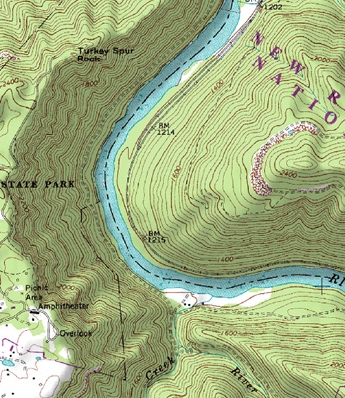 However, if you do not have a georeferenced model and you can't get your survey crew out to the field in a timely (and cost-effective) manner, you can always approximate the extension of your cross sections using a USGS topo map.
These "Quad" maps can be found for free on-line for any location in the US. In fact, there are similar topography data sets for just about the entire world-available on-line for free. The downside is that their resolution is quite inadequte for typical river modeling, and they don't include bathymetry (underwater topography). However, for the purposes of extending your cross section to high ground, this can be an acceptable alternative to a physical survey.
Simply find and download a terrain map that covers your area of concern. Locate your existing cross section line on that map. Then extend it to high ground, marking the locations where your cross section line crosses contour lines. Note the elevations, and the relative distances between contours, then manually enter that data as new station elevation points.
What are the implications of having a cross section that is too short and doesn't extend all the way out to the highest computed water surface elevation? Does it affect the results? Take this cross section for example. It is missing much of the left overbank (presumably).
 |
| Image courtesy of Adam Bohnoff |
First of all, when RAS encounters this situation, it will automatically extend the last station elevation point vertically to the height of the computed water surface. This adds a so-called "vertical wall" to the end of the cross section. Additional wetted perimeter will be included for water that comes into contact with the "vertical wall".
So what does this mean? Well, you will be missing out on wetted area-possibly a LOT of wetted area. Maybe it's negligible. It's up to you to decide. For typical rivers, the added wetted perimeter associated with the "vertical wall" will not make much of a difference in the results. If you plan on mapping the computed flood plain in RAS Mapper, or in GIS using the GeoRAS extension, you'll miss out on some areas that should be shown as inundated.
I see a few possible scenarios that you would need to consider. Your course of action will depend on whether your model is steady or unsteady, and how much error you're willing to accept at this location:
1. The missing wetted area is actually very small. Either the maximum water surface elevation just exceeds the end point or perhaps there is a bluff just to the left of the first station elevation point that would contain all of the water. In this case, you probably don't waste time getting additional survey data and leave the cross section as is, or you manually approximate in a station elevation point to capture the bluff.
2. There is considerable flow area that is missing, but it is so far out in the overbank or it's in a flow separation area and it can all be considered ineffective. In a steady flow model, you can probably leave this as is. Ineffective flow area is ignored in steady flow computations. The answer will be slightly different if you extended the cross section and put in an ineffective flow trigger. This is strictly due to the difference in quantified wetted perimeter. For typical rivers, where the width is much greater than the depth, this will make little difference in your results. For unsteady flow, there could potentially be a huge error in the results if you leave the cross section as is. In unsteady flow modeling, ineffective flow areas are accounted for as hydraulic storage in HEC-RAS. Hydraulic storage will attenuate the flood wave as it progresses through a system. Omitting available storage can significantly affect both the propagation and attenuation of your flood wave. I strongly recommend extending the cross section to high ground in this case.
 |
| For steady flow, the differences in RAS will be very slight between these two options, limited to the wetted perimeter computed added at the vertical wall (ineffective flow assumes a frictionless boundary). In unsteady flow, these two options could produce VERY different results. |
3. There is considerable flow area that is missing, and it is actively conveying flow. In this case, steady, or unsteady, you'll want to extend the cross section to high ground. Omitting this portion of your cross section will have a direct impact on the computed water surface elevation. The degree to which depends on how much of the cross section area you are omitting, but it could be quite significant.
So...how do we extend the cross sections? In a perfect world, you'd have your survey crew go out and get you more points. Unfortunately this cost money and takes time, frequently both of which you don't have an excess of when doing a hydraulic model study. If your RAS geometry is already set up in GIS and your terrain model extends far enough laterally, you could simply extend the cross section cut line to the high ground and reimport into RAS. Easy!
 However, if you do not have a georeferenced model and you can't get your survey crew out to the field in a timely (and cost-effective) manner, you can always approximate the extension of your cross sections using a USGS topo map.
 These "Quad" maps can be found for free on-line for any location in the US. In fact, there are similar topography data sets for just about the entire world-available on-line for free. The downside is that their resolution is quite inadequte for typical river modeling, and they don't include bathymetry (underwater topography). However, for the purposes of extending your cross section to high ground, this can be an acceptable alternative to a physical survey.
Simply find and download a terrain map that covers your area of concern. Locate your existing cross section line on that map. Then extend it to high ground, marking the locations where your cross section line crosses contour lines. Note the elevations, and the relative distances between contours, then manually enter that data as new station elevation points.
Excellent article, Chris!
ReplyDeleteRobert
Thanks!
Delete..And what happens if we dont have topographic maps (Europe) and the terrain data hasn't high ground on both sides to capture the floodplain? Do you suggest editting cross sections..something like moving the 2 or 3 points higher from the W.S. ?
ReplyDeleteOne more great article..Thanks!!
In that case, I'd say do you best to approximate how the floodplain extends out away from the river. If nothing else, Google Earth can give you very rough approximations of elevation and distance.
DeleteOne more question please..
DeleteIn a small depth river (about 1,5 meters depth) the W.S. rises above banks for 0.5 meter (or less) but the left and right overbanks are straight and extending 5km both sides (flat land), so the cross section needs to extend 10km to find hιgh ground. Its an agriculture area with same manning values both sides of the river.
Is there any possibility the flood plain to extend 10km?? In steady flow lets say ok..but for unsteady i think not!! HEC says that it would extend. What is your opinion in this case?
In this case the time it takes for water to travel the 10 km becomes important. You will set up a hydraulic gradient lateral to the axis of the main channel. Here I would suggest not extending your cross sections for 10 km, but rather put in storage areas to cover the flood plain extents. Even better, use a 2D area, then you'll be able to model the lateral gradient and progression of the flow through the floodplain.
DeleteThank you so much Chris!!!!
DeleteChris,
ReplyDeleteI am setting up my geometry using HEC-geoRAS. After creating the ineffective flow areas polygon, when I select the 'Ineffective Flow Areas - Positions' options, I get the following weird error:
"-2147467259, Cannot open any more tables."
Have you ever encountered this before? Is there a solution? Any suggestions or help are appreciated.
Also, my apologies if this is not the correct place to post this question.
Thanks,
J
HI J. I'm not sure what that is. I've never seen it.
DeleteIm encountering the same problem, when calculating lengths/stations with HEC-GeoRAS to my stream centerline. What do I do? Have you found a solution?
DeleteI'm encountering the same problem, when calculating lengths/stations to my stream centerline. What do I do? Have you found a solution?
DeleteI also encountered the same problem while calculating lengths/stations. Any help?
DeleteI think that's a HEC-GeoRAS bug. It happens when it reads the table or featureclass using a cursor without releasing the memory attached to the cursor after finishing the job. You could download a latest version of HEC-GeoRAS compatible with your ESRI ArcMap.
DeleteI think it's a common issue of using the ESRI ArcObjects incorrectly in HEC-GeoRAS. You may need to get a new version HEC-GeoRAS compatible with your ESRI ArcGIS.
DeleteHi Chris!
ReplyDeleteIn your statement here:
"If your RAS geometry is already set up in GIS and your terrain model extends far enough laterally, you could simply extend the cross section cut line to the high ground and reimport into RAS. Easy!"
Questions:
1.Do you mean that I just have to open the geometry file in GIS and manually extend the cross sections I considered that needs to reach hh ground using hec-georas?
2.Will it not cause any problem in creating the cross section lines and upon importing it to hecras?
3.Are the 'extension xs lines' needed to follow the direction of drawing it upstream to downstream?
4.If I have to do it to all the cross section lines I initially had from a previous project. Is there a way to speed up the process? Or would you suggest that I just recreate every xs line?
Thanks for all the help!
- Allan Reyes
Allan-
Delete1. Yes.
2. No. Just reimport it into the geometry file. If you maintain the same river stationing, RAS will know to replace the old cross sections with the new ones.
3. Cross sections are drawn left to right, from the perspective of looking in the downstream direction. Stream centerlines are drawn from upstream to downstream. As long as you follow these rules, you'll be good.
4. Not really. It is what it is.
Good luck!
Chris