
Written by Chris Goodell, P.E., D. WRE
Copyright © RASModel.com. 2009. All rights reserved.
*Update: This post is outdated now with the release of HEC-RAS Version 5 and higher. RAS Mapper is now completely different.

On the main HEC-RAS window, go to GIS Tools...Floodplain Mapping. I know, there is no "GIS Tools" menu item on the main HEC-RAS window. In the next release (4.0.1) there will be. This will bring up the RAS Mapper. It looks like a very basic version of ArcGIS. By default you'll see your river and cross sections plotted in plan view. One of the tools allows you to define a projection, but if everything is consistent, you can bypass this and go right to mapping. Here, you'll be able to bring in your terrain model.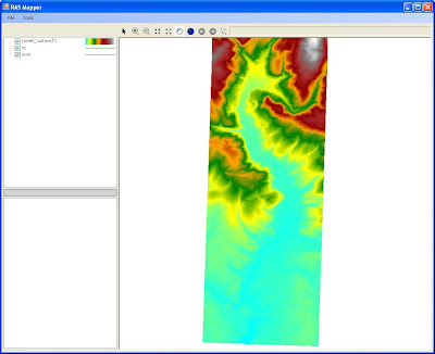 This is seriously way too easy. Next you simply click on the profiles you want to map and click "Generate Layers." There you'll see all of the floodplains and associated depth layers that you requested. The only thing missing...animation of the RAS Mapper. Maybe if I ask real nice they'll put that in.
 This is seriously way too easy. Next you simply click on the profiles you want to map and click "Generate Layers." There you'll see all of the floodplains and associated depth layers that you requested. The only thing missing...animation of the RAS Mapper. Maybe if I ask real nice they'll put that in.
Floodplain Map

Depth Map.

Great inside scoop, Chris! I hope they'll fix some of the other buggies in it :)
ReplyDeleteYeah...me too! But this RAS Mapper looks very cool.
ReplyDeleteI'm guessing you's still need ArcGIS to edit your floodplains?
ReplyDeleteHey, Chris G. et. al.-
ReplyDeleteJust came across your blog. I was thinking to myself, "I wonder if anyone has started a blog devoted to HEC-RAS?", and one Google search later, bingo. I'll be checking out the forum, also.
Nice post on 4.0.1. I am looking forward to the increasing ability to work with GIS info directly in RAS.
Kurt-
ReplyDeleteYes...you're right about that. Any smoothing of the floodplains or other advanced GIS editing techniques will still have to be done in GIS software. Although I think the idea is that HEC will, over time, add more and more GIS editing capability to the RAS Mapper. The nice thing for AutoCAD users (or other GIS software users) is that you are not forced to use ArcGIS now. You can simply open the shapefile(s) created in the RAS Mapper and "edit away" in your favorite GIS software application. In previous versions of RAS, you had to use HEC-GeoRAS, which is an extension to ArcGIS to create your floodplain maps (or other expensive 3rd party software apps like RiverCAD).
Chris (Hauser)-
ReplyDeleteGlad you found the blog. Check back often.
Chris
The HEC-RAS website demonstrated a animation of "Flood inunation", show dynamically showing the inundation area, and the text said it is made by using HEC-RAS. But I cannot find this function in RAS. Anynoe can help?
ReplyDeleteI believe what you saw was made with GeoRAS within ArcGIS (or ArcView). To do this, you need to have ArcGIS, spatial analysist, and 3d analyst, as well as GeoRAS. Alternatively, the RASMapper can do a lot of this completely within HEC-RAS.
ReplyDeleteHi, Chris G.
ReplyDeleteSorry but, how can I generate the .flp archive? I use Hec-GeoRas to introduce geometry into the models, but I don't be able to export the bynari file requested by RAS Mapper.
The .flt file is a floating point grid. It can be generated in ArcGIS or other GIS applications. It cannot be generated in the RAS Mapper (yet).
ReplyDeleteHi there
ReplyDeleteHow the .flt terrain file looks like?
ENZ separate with spaces?
.FLT is a binary float format, not comma-delimited or space-delimited ENZ or XYZ.
DeleteBeing that I am limited/stuck with using Microstation Inroads and no GIS software is there any way to convert the info in a .dtm file to a .flt file. Thanks
ReplyDeleteNot sure how to do it with Inroads. Do you know anyone with ArcGIS that can convert it for you?
ReplyDeleteDoes anybody of you has the same problem that RAS Mapper crashes while generating layers and might have anybody a solution for this? Thanx
ReplyDeleteHi, I have the same issue with Ras Mapper in HecRas v 4.1.0, did you find a solution?
DeleteHello... I have got some results from HECRAS, for instance, depth, velocity,etc...But they are not having unit like 150 meter, feet,etc...can any one suggest me.
ReplyDeleteMasood
Regarding RAS Mapper crashes - here are a few troubleshooting strategies.
ReplyDelete1) After doing a model run, don't change your geometry before using RAS Mapper -- this can cause a crash.
2) Check that you can generate the interpolation surface. Errors can happen here if you have some cross-sections which don't intersect the river centreline (e.g. as a result of interpolating cross-sections over a coarsely resolved channel).
In this case, RAS Mapper should report which cross-sections are producing the errors in the lower left panel. You'll need to fix them and run the model again.
3) Make sure you have saved your project after running the model that you want to map. Do this before using RAS mapper -- otherwise it seems to crash.
why am i getting the same flood extent for different discharge values in hec ras
DeleteThanks Anonymous (May 28th, 2012). Very good strategies for RAS Mapper!
ReplyDeleteRAS Mapper also seems to crash if the model contains storage areas which are not connected to anything.
ReplyDeletei am new to HEC-RAS and am learning by doing.
ReplyDeleteis anyone aware of a good forum that i can post questions on?
the manual i have been workign with is not very informative.
thanks all
Yes. You can post questions to http://forum.rasmodel.com/.
ReplyDeletegood luck.
how can v generate a geometry in HEC RAS
ReplyDeleteBy manually drawing in your stream line components and adding cross sections one at a time, or by setting up layers in ArcGIS and importing them to HEC-RAS via the HEC-GeoRAS extension to ArcGIS.
DeleteHello please how can I get the HEC-GeosRAS extension in ArcGIS 10.1? Can you help out?
DeletePlease visit this page: http://www.hec.usace.army.mil/software/hec-georas/downloads.aspx
DeleteI have not encountered that before. Sorry. Anyone else out there have this happen?
ReplyDeleteThis from one of our GIS Analysts: "I’m assuming it is the result of differing projections. Did the RAS geometry undergo any transformation when imported into RAS, i.e., units converted from meters to feet? If the same transformation is not made on the DEM prior to it being converted to FLT and added to RAS Mapper, there will be alignment issues."
ReplyDeleteHi,
ReplyDeleteI am trying to export encroached cross sections to map the flood fringe, but when I generate the layer it delineates the top of bank instead. Do you know how to fix this?
Thanks!
Could it be that your encroachment is set (or computed) to top of bank everywhere? Maybe that is why it is delineating the top of bank as the floodway boundary.
DeletePlease I need the way to transform Raster or Tin surface to float, because Arcmap don't export correctly (I`m not sure) when RAS Mapper upload the file, there is an error frequently. Problably there is an application or a specified secuence. Thanks a lot for your attention.
ReplyDeleteThe arcmap tool should work fine. If it’s not showing up in RAS mapper it could be because it’s in the wrong projection (or not projected) or it could be too large. Also, this is a long shot, but you may want to check your Windows International Settings and make sure they are set to English (U.S.).
DeleteHi everyone. Can any one advice me what to do when the RAS mapper doesn't show any result. HEC-RAS runs fine but when I used the RAS mapper, there is no image being shown
ReplyDeleteAre you using 4.1 or 5.0 beta? Either way, please read the steps carefully and make sure you are precisely following the procedure for remapping. 9 times out of 10, when this happens, it's because a step in the process was skipped and done incorrectly. Also, make sure your terrain isn't too large. Over 4 Gb and you will have issues.
DeleteAh. That must be why this isn't working for me. My *.flt is over 4 Gb. I guess I need to use a coarser grid??
DeleteThe newer beta versions of 5.0 can handle flt files over 4 Gb. It will still take some time to process, but you should be able to do it. Grab the Sept 2015 beta version from main page of The RAS Solution in the Links section, if you don't already have it.
DeleteHow come when i generate layers using ras mapper, the terrain layer is not visible in the map area? i hav set its symbology and still not visible. only the transition lines, cross-sections and the river is visible in the map area.
ReplyDeleteIn the windows tree on the side, make sure that both the "Terrains" box and your specific terrain within the "Terrains" are checked. Also, make sure there is not another layer on top of the terrain (i.e. an aerial photo). Other than that, I'm not sure.
DeleteFor some reason when I press generate layers, it creates nothing. I have followed everything exactly to the tutorial. but it shows no water surface. I see it doesnt even create the shape file. Some advise would be appreciated.
ReplyDeleteIs your projection correctly defined? that could be the issue. Also, if the terrain is too big, RAS 4.1 has issues. You should give it a go in version 5.0 beta. You can download here. Although still a beta version, RASMapper is much better and easier to use. Make sure to follow the document "Combined 1D and 2D Modeling with HEC-RAS"
Deletehttp://hecrasmodel.blogspot.com/2014/06/update-to-hec-ras-50-beta.html
Thank you Chris it helped a lot. Cheers. Now I get the Depth file but I can't get a shape file to export it to Civil. Maybe in my model the water suface is too small and in some places it is cutted. I will follow the manual now,
ReplyDeleteHi there! I am having problems to export my floodmap into a shape file now. I can see it in the RAS Mapper Menu, but when i select export layer to a shape file it doesn't create any file. I have tried with all the export layer options and i have no exported file. It doesn't even throw any error message. I'm using HEC RAS 5.0 beta. I hope someone can help me. Thanks!
ReplyDeleteYes, some of those features are not yet available in 5.0 Beta. They should work fine when the official 5.0 version comes out.
DeleteI've experienced the same issues. Exporting shapefiles does not currently work. Awaiting the new 5.0 version!
ReplyDeleteWhen will the hydraulics reference manual and applications guide for hec ras 5 be out. please reply. Thanks in advance.
ReplyDeleteNew manuals will come out with the official release of HEC-RAS 5.0. The release of HEC-RAS 5.0 is soon. I don't have an exact date, but they are very close.
Deletehi there, can anybody tell me how to create a .flt raster data set. I just have QGis and no ArcGis, but as you sad, there is a way also for other GIS Software than ARCGIS. Thanks for your help
ReplyDeleteI found already a solution. I worked with esri.hdr labelled raster (*.bil).
DeleteDoes anyone know where to find documentation for the RAS-Mapper Controller? I need to be able to automate export of the flood outline shapefile when Hec-RAS is finished.
ReplyDeleteIt doesn't exist...yet.
DeleteHi my name is Ricardo, i´m working with the Ras Mapper in a river of my country (Panamá), the layers are georeferenced because I exported from arcgis, i convert the terrain to use in ras mapper and i find the projection on internet to use a background image. But when i want to run the model on steady flow the following message appear: "Maps not computed: Unsteady simulation did not complete".
ReplyDeleteIt's quite confuse because I´m working with steady flow and this message warning me abou the use of unsteady flow. I try to follow the chapter 9 in the manual but it wasn´t very clear the explanation in that part.
Additional i want to ask you if you give presencial courses using this models out of your country.
Thanks
Ricardo- That sounds like a bug. Have you tried the official and final release of HEC-RAS 5.0? http://hecrasmodel.blogspot.com/2016/03/hec-ras-50-official-release-is-available.html
DeleteAnd yes, we do teach HEC-RAS courses anywhere. Please email me if you would like to discuss HEC-RAS courses in Panama.
Deletecgoodell@westconsultants.com
Thanks for you reply Chris, already download the 5.0 and following the chapter 9 no problems with the results, except with the velocity layer, it doesn't shows up. I runnning the model in steady flow mixed flow, I was viewing an example in Baxter river and i can see te results (subcritical flow). So, it can be something with flow condition?
ReplyDeleteThanks
Ricardo
It should be there. Make sure you have everything "checked" and nothing is covering the velocity layer.
DeleteOn my own project using RAS Mapper in HEC-RAS 5.0.0, I've got good results for Depth and WSE but not velocity. The velocity layer is astericked and it says "One or more errors occurred".
DeleteTry removing the velocity layer, closing RAS Mapper, then reopening. If that doesn't work, try removing the velocity layer than rerunning RAS.
DeleteHello, I'm having the same problem as people above. I'm using 5.0.1 version with steady flow simulation. I just can't get it to show velocities. It says "One or more errors occurred". Funny thing is that I've managed to get velocities layer once, even particle tracking and velocities arrows, but I can't replicate that now. Any advice? Thanks!
DeleteThe only thing I can suggest is to delete all of your results layers in RAS Mapper. Then rerun HEC-RAS and see if it shows up.
DeleteI'm having the exact same issue! Depth, water surface elevation, and inundation boundary results are displaying in RAS mapper. Velocity will not. The error in RAS Mapper is "Unhandled exception: one or more errors occurred". I tired deleting per your instructions but no change. Velocity is being displayed in the cross section editor. Did anyone find a fix or have a suggestion on this?
DeleteIf DEM does not give correct bed level of the river bottom , why do you you suggest using it for geometric datat extraction in HEC-geoRAS?
ReplyDeleteI use it for the "above water" terrain. Then I merge in the river channel, which is typically surveyed using traditional site and rod or with more sophisticated acoustic devices.
DeleteSo, that means that HEC-geoRAS alone does not suffice to generate all the required geometric data required to be input to HEC-RAS. If that is the case, then why is there no mention of it in the HEC-geoRAS tutorial because it was misleading for me as a novice in the field of spatial data analysis tools?
ReplyDeleteAlso, if you have bathymetric data from other techniques, and HEC-RAS does not take into account the shape of the channel, so why bother working in HEc-geo RAS at all. Thank you for your patience.
HEC-GeoRAS is a tool that preprocesses GIS data in a form that can be read into HEC-RAS. HEC-GeoRAS does not create the DEM for you. HEC-GeoRAS is developed for users of GIS that have some experience. If you are having trouble understanding the GeoRAS process and what it can be used for, I suggest taking a course in GIS and becoming a little more experienced. Then it will make a lot more sense to you, and the benefits of using HEC-GeoRAS to speed up input data preprocessing for HEC-RAS will become clear to you. But, if HEC-GeoRAS is not your cup of tea, there's no requirement that you have to use it.
DeleteI know GIS does not create DEM but I do not know a lot of other things. Thank you. I need to get my basics right with GIS before staring anything new. But the bottom line is that in order to create an accurate model, other methods of measuring river bed profile has to be adopted too, isn't it? Pardon my obtuseness.
ReplyDeleteThat's correct, unless your stream depth is very low at the time of the topographic survey, in which case you might be able to ignore the underwater topo. Some people will approximate, and then even calibrate the river bed below water, rather than going to the effort to do a hydrosurvey. Others will be lucky and will find older cross sections from a previous study that they can blend in with their newer terrain.
DeleteI have developed 5 profiles of 5, 10,25, 50 and 100 years in HEC-RAS; however, all of these profiles give a similar extent. I don't understand where i am making a mistake.
ReplyDeleteHi. its my first time with HEC-RAS.I'm modeling flood in flat terrain in Nepal. The channel geometry from 5m resolution TIN doesn't look good. so I want to edit all the cross-section from hec georas with the field survey data. How can I operate it? further more I have tried to run model without editing all the things run good but when importing ras export data in hec georas some error occurred. and if not while executing flood plain mapping cant convert TIN to raster problem exists. and sometime "com....." problem also exists and fail to draw result. please help me to solve these problem.
ReplyDeleteRead this: http://hecrasmodel.blogspot.com/2008/12/merging-ground-survey-with-dtms.html
DeleteHi. I'm new in HEC-RAS. i have cross-section from hec-georas which cant represent the channel geometry as it is from flat terrain and of low resolution TIN. so that i want to edit the cross-sections within the channel only with fild survey data. how can i execute it? and although the unit set in SI unit the plot unit is in feet. How can i change it to meter? thanking you rc
ReplyDeleteI have a latop Acer aspire 5315 , windows 7 , 32 bit , 2giga ram , I installed the HEC RAS 5.1 but no runs , throws an error saying that no mapper loaded the flush , and error 91, what can I do?
ReplyDeleteCould be a conflict on your computer. I would try reinstalling RAS. If that doesn't work, see if it works on a different computer. That would at least tell you if your Acer has a conflict.
DeleteGraccias, si en efecto corre en la miilatop acer de mi esposa. Ahora, pude instalarr la version 4.1 que tiene una pestañana de GIS tools, me pregunto si en esta versión se puede correr los ejemplos de 2D?
Delete
DeleteHEC- RAS 4.1 no se puede hacer el modelado 2D . Sólo la versión 5.0 .
I have a latop acer aspire 5315 , windows 7 , 32 bit , 2giga ram , install the HEC RAS 5.1 but no runs , throws an error saying that no mapper loaded the flush , and error 91 what can I do?
ReplyDeleteMe pregunto si hay casos realizados para aplicar cuando existe una represa en el tramo etudiado
ReplyDelete
DeleteHay algunos problemas de ejemplo que vienen con HEC-RAS que tengan presas.
Some can help me to export the results hec ras 2d (depth, velocity, etc) to ArcGIS
ReplyDeleteChris,
ReplyDeleteI am trying to create a 2D model, and I am not able to create computation points for some reason. It states current mesh contains no computation points. Any idea on how to fix?
hello, I am working on HEC RAS 4.1.0 and my result in RAS Mapper for the river is not continuous. The river split into two and meet again just before it reached the mouth. The result in the RAS Mapper is that water at the junction of where they meet again is not continuous or does not connect with the river water near the mouth. The elevation at the discontinued part is also negative. I am wondering why there is no water on that area. Can anyone please help?
ReplyDeleteSame problem here. I am using the same version too
Deletehello ,
ReplyDeletei am new to HEC-RAS 2d and would like to model a creek. I created a DEM from th tin which i created from the coordinates obtained from google earth . My problem is i could not generate the mesh in 2D flow area . I tried to use version 5.0, v5.0 beta and 5.03 but this all version are giving me the same issues . i would be happy if any one could give me the solution of hy the mesh is not creating ?
Thankyou
I'm facing the exact same problem. I would be happy if you can help me on this.
DeleteTry getting the new 5.0.4 version from the HEC website. Hope that helps!
DeleteHello,
ReplyDeleteI'm using RAS Mapper to simulate a floodplain (on steady flow). I already have the result but I need to export the floodmap to a shapefile (or raster, or something that needs to be open by autocad). I tried to store it by editing the results map parameters (with the raster based on terrain option, then saving the map, and then clicking computing/updating stored maps) but I get an error saying that it could not open the file.
Can you help me with this issue?
Hi how can I solve this problem?
ReplyDelete"Error creating Terrain: Value was either too large or too small for a Single"
Can some one please help me?
hello I do not speak much english I gsutraia that you support me with download the ras maper work in water resources in Peru my email is moisespaytan@gmail.com
ReplyDeleteHi Chris,
ReplyDeleteI recently came across this blog about a software called GeoHecRAS from CivilGeo, which is claimed to do eveything that HECRAS can do with more efficiency. I was just wondering whether you might have any experience on this and probably give some advice.
Hello Chris,
ReplyDeleteI've been trying to create and export an inundation map in RAS Mapper for use with arcmap. WSE map is easily created with the model, but for some reason I cannot create an inundation map and export it in shp format. I'm missing a step or two...please help. I did notice the terrain source file does not show when viewing the the layer properties. Frustrating...
Yes there are a few more steps. You have to go to Add New Results Map. Then select the map you want to make but make sure you select a single profile and one of the options on the right to make a static map. Once that static map is computed, you’ll have access to it as a grid or shape file, whichever one you selected.
DeleteSo under the Results Layer, I right clicked on CE plan and selected Add New Results Map Layer, then selected Inundation Boundary (map type), 100yr Fut (steady profile), and automatically the Stored (saved to disk) map output mode selects the Polygon Boundary at Value: 0, and I select Add Map. The inundation map layer shows up as a geom layer, and I right click on this layer and select compute/update stored map. The layer changes to italics and a red * with the disk symbol states "stored map files not found." Gone thru these steps several times with the same results. For some reason it's not computing the inundation map. What else can I do?
DeleteSolved!
DeleteI was having the exact same issues. I could display depth, flow, WSE, etc. maps but if I tried to make an Inundation Map of 0 ft depth, I received the same error. Here's what worked for me:
My RAS-MAPPER terrain was a .tif file exported from ArcGIS but the original terrain was LiDAR I downloaded from TNRIS. LiDAR has been known to have lapses (holes) in the surface files. I re-opened the terrain file in ArcGIS and ran the FILL command. The FILL command goes through and fills in imperfections in the terrain (sinks and peaks). I suspect there were imperfections that kept HEC-RAS from properly computing depth in certain spots. I also trimmed the terrain to a smaller boundary to reduce the file size though I don't think this is what fixed it.
After running this command, you should be able to bring this updated terrain into RAS-MAPPER. You'll probably need to spend some time updating your geometries because the terrain will be altered slightly.
A new version of RAS just came out. 5.0.4. Try installing that and see if it helps.
ReplyDeleteI am having problem in my installation of Hec-ras 5.0.5 or 5.0.4. when I click main menu GisTools/Ras Mapper ... there is no menu Ras Mapper loading or displayed .. help me please...
ReplyDeleteHello,
ReplyDeleteI am using RAS Mapper and I get the terrain but it doesn't connects with google satellit
Whats might be wrong?