
Written by Chris Goodell, P.E., D. WRE | WEST Consultants
Copyright © RASModel.com. 2008. All rights reserved.
When I have a digital terrain model and some ground survey (or more specifically, hydrosurvey) points, I like to make use of the merge tool in RAS found in the graphical cross section editor. The first thing you have to do is bring your ground points into GIS. Then, cut all of the cross sections you want in GIS, making sure to account for changes in roughness, channel shape, bed slope and to satisfy numeric requirements. Also, be sure that you cut a cross section over each of the sets of groound survey points. It's important that these are located in the same position (as shown below).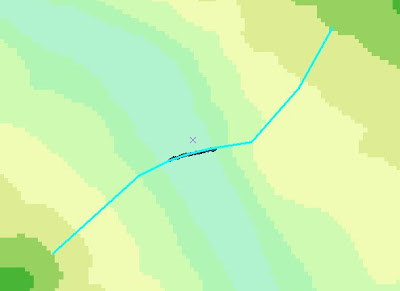

Create 2 geometry files. One with only the ground surveyed cross sections, and one developed from the DTM. In the ground surveyed geometry file, you'll want to interpolate cross sections so that you have a matching cross section for each DTM-created cross section. The interpolation routines in HEC-RAS work great here. They'll allow you to actually specify where you want the interpolated cross section to be (in this case, select the location of it's matching DTM section). Now you'll have two geometry files with the same number and identically-stationed cross sections. Only one file will be strictly ground survey points and the other will be terrain model points.
Now, open the DTM geometry file, and go to the graphical cross section editor. 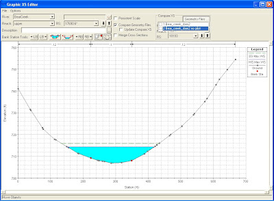 Select the Compare XS Geometry button and select the Ground Points Geometry File. Because you properly interpolated sections to match the DTM geometry, the River Stations for both geometry files should line up. Now click the Merge box. For each cross section, simply shift the main channel (ground points geometry) until it lines up with it's DTM counterpart cross section. You can do this by manually entering an offset distance, or by holding the shift key and pressing the left or right arrow key. Once you have them lined up, move the red merge boundary lines until you have the main channel sitting squarel inside them. Hit the merge "Inside" button and the newly merged cross section has been created.
 Select the Compare XS Geometry button and select the Ground Points Geometry File. Because you properly interpolated sections to match the DTM geometry, the River Stations for both geometry files should line up. Now click the Merge box. For each cross section, simply shift the main channel (ground points geometry) until it lines up with it's DTM counterpart cross section. You can do this by manually entering an offset distance, or by holding the shift key and pressing the left or right arrow key. Once you have them lined up, move the red merge boundary lines until you have the main channel sitting squarel inside them. Hit the merge "Inside" button and the newly merged cross section has been created.
So I just got off the phone with you, then got online to look up some RAS info and stumbled across this. What a coincidence. Nice Blog!
ReplyDeleteCool Riley. Glad you found it. Check back often and feel free to leave more comments. I want this to be interactive.
ReplyDeleteBy the way...congrats on your new little one!!!
Hi Chris,
ReplyDeleteI am trying to do everything exactly like you described, but these are my issues:
1) When I interpolate the ground surveyed cross sections as perpendicular segments, the cross sections do not have the exact same angle of the DTM-created cross sections.
2) When I click in Compare Geometry Files in the editor of the DTM geometry file, HEC RAS does not allow me to choose the Ground Section Geometry File. It just allows me to choose the DTM geometry file that is already opened, and the cross sections are the same, of course.
Do you know what I am doing wrong?
I am learning how to use HEC RAS by myself and your blog has really been very helpful to me.
Many thanks!!!
It sounds like RAS is not recognizing the ground survey geometry file. If it indeed exists, you should import it to your project. Then it should show up for comparing. From the main RAS window, File...Import HEC-RAS data.
DeleteYou might find this article helpful: http://hecrasmodel.blogspot.com/2014/12/including-channel-bathymetry-into-your.html
Hi Chris. The problem was that I was not really opening my ground survey geometry file. I thought that clicking on Compare Geometry Files I would open it, but actually, we have to open it on the Geometric Data window (File > Open Geometry Data). I was not aware that we can have two different geometry files in the same project. Once I had my two geometry files, I was able to compare them. Thanks!
DeleteGreat! Thanks for sharing.
DeleteI have a HEC-RAS model with no terrain data and a Surface generated in Civil 3D supplied by the city in the area of interest that I can bring in as a terrain. I would like to adjust the Civil 3D surface/terrain to match the cross-sections from the HEC-RAS model. The water surfaces I create in HEC-RAS associated with the terrain I brought in do not match the extents of the water surface in the cross-sections. I am looking fro suggestions on how to extract the cross-sectional data so that I can merge it with my surface/terrain.
ReplyDelete